The following link is a playlist in YouTube which shows Tracey's reports in sequence. Be ready for about eight minutes of reporting!
Sunday, November 9, 2014
Sunday, October 26, 2014
Bringing It All Together
Joan Presecan proposed making a book of the trip and I think that's an excellent idea and I will help. Blurb publishes quite high quality books at reasonable prices. There are other excellent publishers as well. We of course will want to talk about this.
We still need more informal pictures of our Crew. Tracey has started a video of our descent down the Fonsrannes Staircase, so we are not quite ready yet, but we can be soon.
(You may ask whether the book can include video and in a real way it can. You upload the video to YouTube and then create a Scanlife barcode link to it in the book. You scan the barcode with your iPad, and - Bingo! - you are watching the video.)
Flickr Accounts and this Blog
Everyone took a lot of pictures on the trip. What's the best way to share them? One way is to email the actual pictures to each other or put them on a DVD. But that uses up resources, is slow - for starters.
Another way is for each person to store one or more pictures online, then share the link. That's quite efficient. Many applications enable you to do this. PicasaWeb is good, so is Facebook. But IMHO Flickr is currently the best.
I proposed that each Canal Trip Member create his or her own account on Flickr and then share links to their photostream or albums. Five members have already done this. Melinda, Dave, Lark Dorothy,Tracey,John Sorcinelli and Larry Olson. Others are in the process or doing so. Here they are:
As I receive these links, I'll update this page. Then everybody can see everybody else's pictures without having to physically transfer them (except to Flickr or course).
Galleries

Flickr makes it possible to store favorite other Flickr members' pictures in a "Gallery". So if you are on Flicker, I can put your photos here. The Gallery will update automatically as pictures are added. All you need to do is get me the link to your photostream. Don't miss this additional Gallery - I ran out of space in the first one!
Informal Person Pics

Here is where everyone can contribute. We need informal pictures from along along the Canal of our mates. I can arrange to put them in this album or link to them.
Excursion - Minerve

An incredible 14th C. city where the Cathars were burned for what was then taken as a heresy. We took a van to Minerve from Homps. Some on the other boat bicycled there with no problem. Take a look at the original cycle route.
The Staircase to Agde

After the Staircase, it's an easy go to Agde. We found a great restaurant at Villenueve les Beziers and some great trompe l'oeil examples as well.
Fonserannes Staircase

Follow this sequence of the gentleman with the white hair and his mate up the stairway. They did a good job.
Capestang to Beziers
I don't have any good pictures of Beziers. There are two wonderful possibilities: the viaduct over the Orbe River and the Staircase at Fonseranne. Anyone step up?
le Somail to Capestang

Here we really need some pictures. I have some, but they are primarily placeholders.
Paraza to le Somail

The pictures are pretty spotty here and the bookstore will show twice. Love to get some additional photos from this area.
Trebes to Paraza

We found a winery at Paraza, and more. This is the site of the Riquet Chateau, the home of the man who designed the Canal in the 17th Century. The Chateau is being refurbished but we were able to slip through a side door in the winery to snap these pictures.
Carcassonne to Trebes

The album says Carcassonne to Trebes, but in fact includes pictures from west of Carcassonne, such as Bram. But the 4th night mooring was at Trebes with its great restaurants along the Canal.
Carcassonne - Our First Look at Locks

A couple of days before we picked up the boat, we watched boats arrive at the basin at Carcassonne to see how the locks worked. In this image we see the lock filling in order to lift the boat in it up to the level of basin. In the sequence of images, you'll see this boat make it into the basin and then a boat from the basin leave it after it is joined in the lock by a second boat.
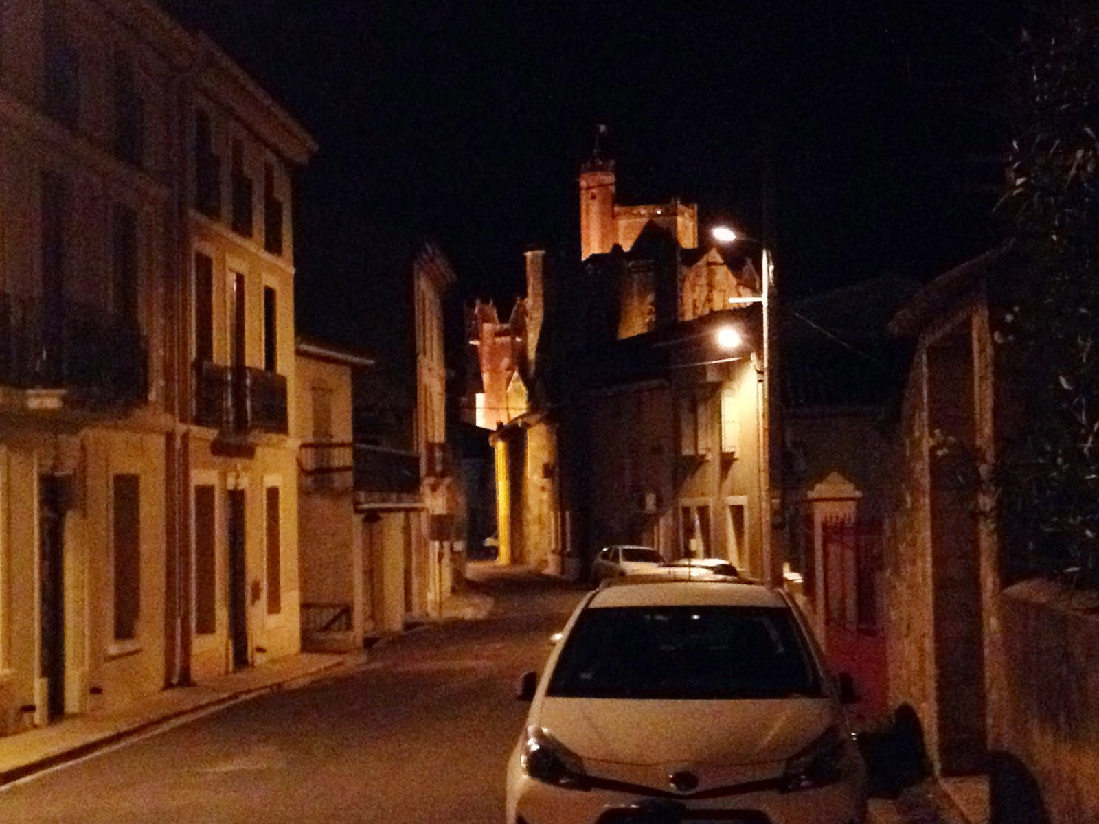
Carcassonne - the Cathedral

An immense and impressive building in itself, but also from its tower, a great place to photograph the surrounding area and the Castle.
Carcassone - Castle

The Medieval part of Carcassonne is called the Cite (with accent). The Castle is part of the Cite.
Carcassonne - the House

Built in 1860, it's large, slept 7, with kitchen, dining room, study, breakfast area, patio, the works. Much fun.
Carcassonne - Pre-stay and Canal Stay

Carcassonne is a spectacular 14th Century City. Many of us stayed there several days before the Canal launch on October 4th. These are among the first photos I took when I first arrived. The link above is to the Flickr album. Click on an image to enlarge it. You'll find that you can move to the next image via the ">".
A Potpourri of Geotags

I was delighted to discover that my iPhone photos were automatically geo-tagged and that all photos could be geo-tagged. When you enter this album, look for the "map" button at the top (lap-top format) or "more info" if you are on an iPad. The former will show you a map with pink icons where your photos are. Click the button and your photo will show up. Click the photo and the icon will blink. Try the map view here.

We picked up our Boat in Castlenaudary October 4th

This is the Great Basin at Castlenaudary. After a (very) brief tutorial on piloting the boat, both boats headed off to the first set of locks. From Castlenaudary there are about a dozen locks to descend during the first day. That's why Gay, or first night, was so close to our start. Click the image to follow our course that day.
We Did It!
Not everyone has returned from points afar, but the Canal du Midi portion has been completed! We are now in the stage of collecting photos for exchange and a commemorative book. In the next postings, I'll be linking the various stages of the Canal Trip to our growing photo database, now primarily on Flickr.
Thursday, September 25, 2014
CLAREMONT
SENIOR BIKE GROUP
Canal du
Midi trip October 4 through 14, 2014
Mesdames et
Messieurs,
Nous sommes
un groupe de cyclistes de Californie du Sud faisant un tour le long du Canal du
Midi en bateau et vélo. Notre club se compose d’ hommes et de femmes ayant
surtout 60 ans et plus*. Nous faisons du vélo 3 ou 4 jours par semaine. La
plupart de membres fait entre 100 et 160 kilomètres par semaine en croyant que
cela nous garde en forme et plus jeunes.
Pendant le
temps que l’on passe en France du 1er au 15 octobre 2014, on aimerait faire
connaissance d’un groupe de cyclistes français d’un certain âge, comme nous, et
qui aimerait établir un amitié pour faciliter des échanges et visites.
Si cela vous
intéresse de nous rencontrer et de parler d’une collaboration, envoyez-nous un
mél, faites un post sur notre blog, ou appelez-nous pour en parler pendant
notre séjour en France.
En espérant
d’entendre de vous bientôt,
CLAREMONT
SENIOR BIKE GROUP
Canal du Midi trip October 4 through 14, 2014
Mesdames et
Messieurs,
We are a
group of bicyclists from Southern California touring along the Canal du Midi by
bicycle and canal boat. We are an active
group of mostly seniors (60 plus) and we ride 3 to 4 days a week. Most of us ride 100 to 160 kilometers per
week. We believe bicycling keeps you fit
and young. We have almost as many women
riders and we men. Last year our club rode more than 160,000 cumulative
kilometers.
During our
time here (October 1 to October 15, 2014) we would like to meet up with a group
of French bicyclists that have similar interests and would be interested in
establishing a friendship program that would facilitate future exchanges and
visits.
If you have
an interest in meeting us to discuss a partnership please send us an e-mail,
post to our canal blog, or phone us, and we may be able to get together while
we are here in France.
Hoping to
hear from you soon,
Wednesday, February 19, 2014
Our Google Earth Placemarks - Where Are They?
Google Earth is where you can find our day-by-day progress on a map. In fact, a continuous map which shows bike excursions, hotels, restaurants, historical points and a lot more. Google Earth shows more than can be shown on this Blog or on Google Maps. But how to get there?
No problem. You can always launch Google Earth and fly to Castlenaudry or Carcassonne or any of the villages we will be visiting. But you won't see our Placemarks unless you have already saved them.
So how do you find them? Click below to download our Google Earth Placemarks.
No problem. You can always launch Google Earth and fly to Castlenaudry or Carcassonne or any of the villages we will be visiting. But you won't see our Placemarks unless you have already saved them.
So how do you find them? Click below to download our Google Earth Placemarks.
THE PLACEMARKS
When you click (or double-click) a bundle of these placemarks are downloaded to your computer. Make a note of where they are. If you have a choice, save this file on your desktop. Double-clicking on this file will typically launch Google Earth with our placemarks. Now you can see where we are going and can examine our trip in detail. Before you leave Google Earth make sure to "save" the placemarks (which are located in "Temporary Places") to "My Places".
If you forget to do this, no problem. The next time you launch Google Earth, just "open" that file you saved on your desktop. It will be named something like "CanalNow.kmz".
That's all there is to it. Now you can see what we are doing on our Canal du Midi trip in Google Earth.
Friday, January 10, 2014
Interesting New Features in Google Maps for Bicycles
Google Maps for bicycles is getting better and better. Not only is it possible to map bike routes but it is also possible to "see" new bike routes.
In addition, it's possible to choose a "map" view or a "terrain" view.
This works here and in France.
To try it, go to one of the embedded maps on this blog. I've chosen this one because it shows all of these features.
Before you go there, remember to keep in mind that you can click the "view larger map" just underneath the embedded map. When you do that, the route will open in Google Maps. Okay, head over there.
When Google Maps launches, you can see (depending on your device) information about the length of the ride and Google Maps' estimate of how long it will take. In this instance, the route is about 13 miles and will take a little over an hour and a half.
Look for "Options" or "Layers" if you are in an iOS device. There you should be able to check "terrain". That will give you something like a topo map.
In the same drop down box, check "bicycle." Now look at the route. You will see additional bike routes in the upper left corner and also down at the bottom. There are three types including dots for "bike friendly" roads. See if you can scope out the other two.
Again in the same drop down box, check "traffic." If there is congestion, that should show in red. (I haven't seen it yet, but it's now late at night in the Castlenaudry area.)
In the cycling Guidebook, this route to St-Ferreol Reservoir is described as "exposed." I'm going to check it for traffic and see if there is any congestion. If there is, then I'd start with the less-exposed route which you can examine here.
Happy exploring....
Thursday, January 9, 2014

Tuesday, January 7, 2014
Another General Overview
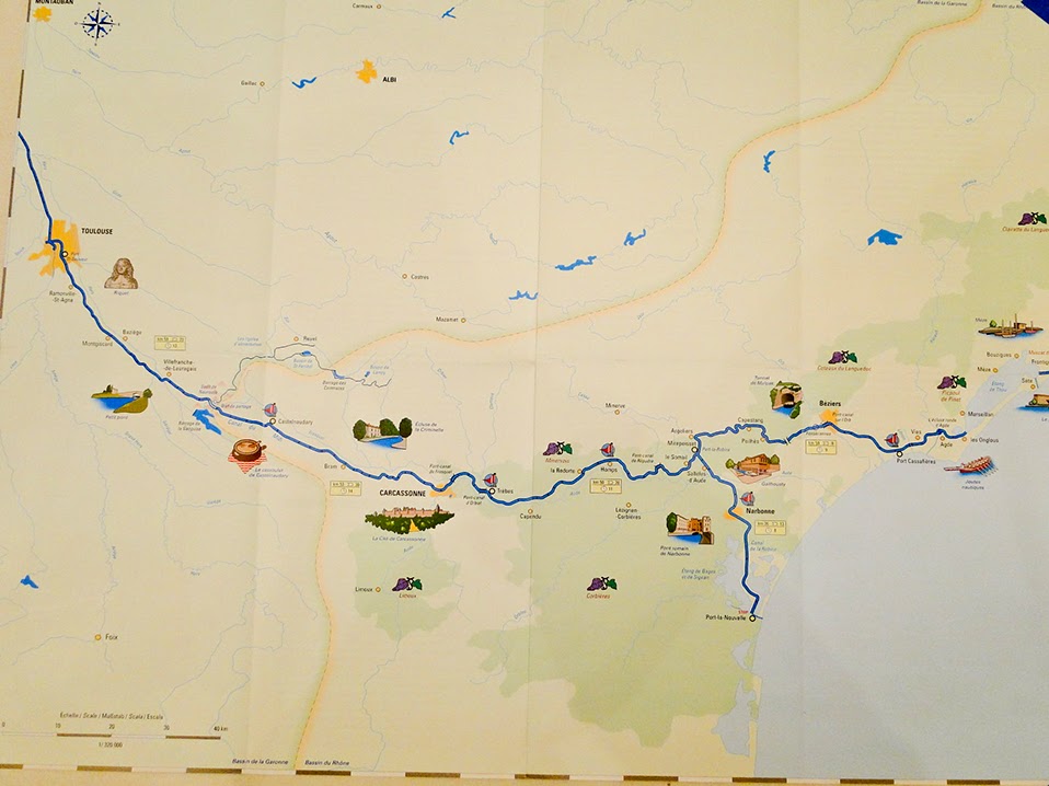 It's new territory, so it helps to be oriented. The overall route is shown at the top of the blog, just under the title (with three excursions). It appears in this map as well. Notice Toulouse on the left and our route east all the way to the Mediterranean. (A cropped version of this map appears here.)
Chart of Daily Progress
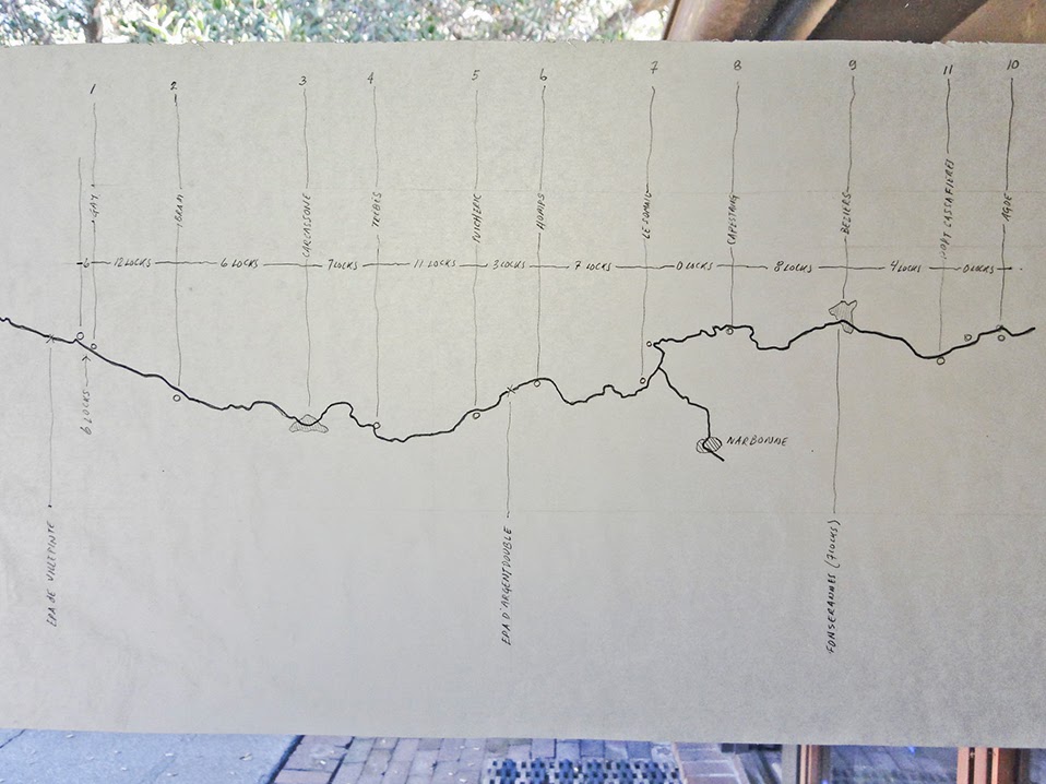 Our Captain John's careful plan for each day's progress along the Canal and through the Locks. (It is not written in stone. :))
Here is the spreadsheet version.
Excursion to Minerve
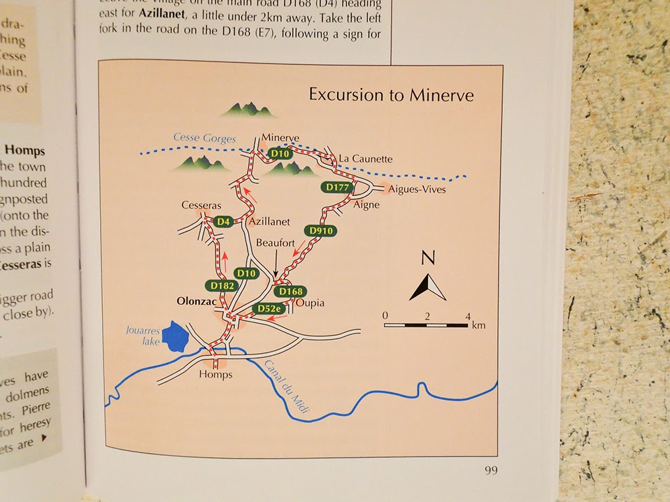 From the Cycling Guide. Also mapped here earlier. (Download-ready to your GPS.)

Rebenty Aquaduct: Sights near the Canal
 One of the many historical features of this National Heritage site.
Castlenaudry (General Area)
 More of an aerial view. (Again, see earlier posts for complementary views.)
Castlenaudry (Detail)


Map Overview
 We will have plenty of maps for the trip. This one shows an overview. Note we will go going from the left side of the map to the right through Beziers.
Subscribe to:
Posts (Atom)